I think the Battle of Verdun is a bit distant in the British consciousness. When it comes to World War I, we have the Somme, we have Passchendaele. The loss of so many of our own men is hard enough to get our heads around. But Verdun is sacred in France and it warrants understanding. Despite writing about the battle every day for the duration of its centenary, I had a lot to learn.
The small yet infamous city of Verdun is nestled in the valley of the Meuse, relatively close to the German border (closer in 1914 than it is today) and on what Major & Mrs. Holt describe as a “classic invasion route” (Battlefield Guide to Western Front – South). The formidable hills surrounding Verdun had been heavily fortified since the Franco-Prussian war of 1870 and so it was in these hills that the Battle of Verdun took place – not in the city itself, which never fell into German hands.
The front here was in stalemate and in April 1915, a serious lack of both men and guns for the active front in Champagne led the French to disarm their Verdun fortifications. In 1916, Germany took the French by surprise. Heavy artillery bombardment began on February 21, big guns firing straight across the valley from German stronghold to French; and so began an onslaught that would last for 10 months. The French Army showed remarkable tenacity, clinging on to their positions at all costs – and the cost was high. Though Verdun never fell, 540,000 French and 430,000 Germans paid the price.
1. Verdun Memorial Museum
“Mum, why did you give birth to me? Why do I have to see all this?”
I have been consistently impressed with the standard of the museums to the Western Front in both Belgium and France and this one still blows me away. It is built right at the heart of the Verdun battlefield and the experience is immersive – from dramatically-displayed artefacts to stirring contemporary accounts, from a 100-square-metre video wall to the floor presented as the littered battlefield beneath your feet.
Beyond the emotive, I enjoyed learning about some of the behind-the-scenes ‘management’ of the Verdun front.
- German soldiers were posted to a particular area for long periods of time and therefore got to know it very well, whereas French soldiers would spend a short period of time in one place and more than likely not return to it again.
- The postal system was a huge operation (and not just on this front). Soldiers were often writing to loved ones multiple times a day – though I knew letters were important, this was much more than I had imagined. I’d assumed that all letters were read by superior officers for censorship before they were sent on but the volume was far to high for that to be the case.
- And something else I had never considered: the families of the soldiers on both sides, here, were just behind the lines and the military had to control access to the front to stop family members trying to get through. This seems so obvious and yet had never crossed my mind before: fighting ‘overseas’ it presumably wasn’t something the British had to consider.
I was probably a little too excited about a double-ended pencil in a display cabinet. When you have spent four years writing about and researching different WWI battles, you get used to seeing maps with zigzags of red and squiggles of blue representing the trench systems of the opposing sides. To find out that there was a special pencil just this purpose was quite a delight.
![Mapping pencil on display at the Verdun Memorial Museum [Copyright 2018: A. Matthews]](https://greatwardiaryontour.files.wordpress.com/2018/09/cropped-img_20180910_131243935_44615776041_o-25.jpg?w=534&h=534)
2. Fleury and the Forests of Verdun
Today, the site of the Battle of Verdun is a vast forest full of shell holes and much of it part of the Zone Rouge, land so polluted by war that it was labelled: “human life impossible”.
Before the war, this land had thriving villages, such as the prettily-named Fleury-devant-Douaumont. As the line had stabilised in this part of France, the residents of Fleury stayed at home – until the bombardment began in February 21. It was pummelled into oblivion by artillery fire and could never be reinhabited. Fleury is one of many officially-named “villages that died for France.”
The residents of villages that fell into German hands were used as labour and food was scarce as the Germans prioritised their soldiers. I visited the remains of Fleury at the same time as a German school group and, having spent the last four years jumping between the past and the present to write the Diary, in that moment I could see the strange juxtaposition: should we be transported back 100 years , we would not have been able to stand side by side. I am so heartened to see young people from all nations are still deeply engaging in their history.
![A path through the destroyed village of Fleury-devant-Douaumont [Copyright 2018: A. Matthews]](https://greatwardiaryontour.files.wordpress.com/2018/11/dscn8216-2.jpg?w=1100)
I recall feeling surprised by the mention of forts in the earlier years of writing the Diary of the Great War. It did not seem like a 20th-century concept to me – perhaps because I live in Britain where forts tend to be medieval constructs (or earlier). However, in European warfare, it seems the fort had been the key line of defence right through the 19th century and that it was during this war – rather than any time before – that the fortress began to seem outmoded.
![An entrance into Fort Douaumont with German, European Union and French flags flying above [Copyright 2018: A. Matthews]](https://greatwardiaryontour.files.wordpress.com/2018/11/dscn8226-2.jpg?w=1100)
To visit both of these sites was both moving and disturbing and yet to see the European Union flag flying alongside the French and German flags at these sites is inspiring. In a place like this, that union feels tangible and important. I can’t help but reflect that whether some other nation wants to be part of that union or not, we ought to support those that need it.
![Destroyed gun turrets of Fort Vaux [Copyright 2018: A. Matthews]](https://greatwardiaryontour.files.wordpress.com/2018/11/dscn8236-2.jpg?w=1100)
At the top of Douaumont, above Fleury and around the corner from the fort, is a French mass grave containing the bodies of 130,000 men. 16,142 individual graves are set out in a sea of crosses in the cemetery in front. The scale of death in this one site is just overwhelming. I came on this trip to try to understand more about the First World War. After 5 days, I stand here now and I think to myself, I give up. It is beyond all understanding.
![The French cemetery and the ossuary at Douaumont [Copyright 2018: A. Matthews]](https://greatwardiaryontour.files.wordpress.com/2018/11/dscn8225-2.jpg?w=1100)
When I came across Mort Homme in the Diary of the Great War, it made me pause. Though it gained its moniker before the war, a place with the name ‘Dead Man’ sticks in your mind. I drive along a dirt track at the edge of a field and enter into dense woodland as the road climbs upwards.
It feels apt that this is the final place I will visit on my battlefield tour, for at the top of Mort Homme in the midst of the trees is a statue of a dead man standing by his tomb, declaring “Ils n’ont pas passé”. They did not pass. Symbol of bitter bloodshed, symbol of resistance, symbol of holding on to what matters. Verdun is a lesson to all about the importance of peace. Farewell, France.
![The memorial at Mort Homme [Copyright 2018: A. Matthews]](https://greatwardiaryontour.files.wordpress.com/2018/11/dscn8237-2.jpg?w=1100)
![Driving the Chemin des Dames [Copyright 2018: A. Matthews]](https://greatwardiaryontour.files.wordpress.com/2018/11/img_20180909_185618756_42770589710_o-2.jpg?w=1100)
![Views from the Chemin des Dames, at the Caverne du Dragon [Copyright 2018: A. Matthews]](https://greatwardiaryontour.files.wordpress.com/2018/11/dscn8200-2.jpg?w=1100)
![Silhouette of Reims Cathedral at sunset [Copyright 2018: A. Matthews]](https://greatwardiaryontour.files.wordpress.com/2018/11/dscn8201-2.jpg?w=1100)
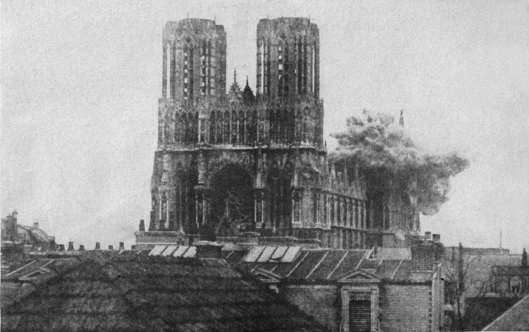
![The distinctive towers of Reims Cathedral today [Copyright 2018: A. Matthews]](https://greatwardiaryontour.files.wordpress.com/2018/11/dscn8210-2.jpg?w=338&h=459)
![Headstone in Connaught Cemetery. [Copyright 2018: A. Matthews]](https://greatwardiaryontour.files.wordpress.com/2018/11/dscn8179-2.jpg?w=1100)
![The road to Thiepval Ridge with the Memorial and village visible from Mouquet Farm (Mucky Farm or Moor Cow Farm as soldiers knew it). The British direction of attack was towards the camera but they had to fight up the hill on the other side of the ridge first. [Copyright 2018: A. Matthews]](https://greatwardiaryontour.files.wordpress.com/2018/11/dscn8176-2.jpg?w=1100)
![Thiepval Memorial to the Missing of the Somme [Copyright 2018: A. Matthews]](https://greatwardiaryontour.files.wordpress.com/2018/11/dscn8168-2.jpg?w=1100)
![Caribou statue at the Beaumont-Hamel Newfoundland Memorial [Copyright 2018: A. Matthews]](https://greatwardiaryontour.files.wordpress.com/2018/11/dscn8194-2.jpg?w=334&h=405)
![Hunter's Cemetery at Beaumont-Hamel Newfoundland Memorial, with the 51st (Highland) Division memorial in the background. [Copyright 2018: A. Matthews]](https://greatwardiaryontour.files.wordpress.com/2018/11/dscn8190-2.jpg?w=1100)
![Ocean Villas Guest House & Tea Rooms, Auchonvillers [Copyright 2018: A. Matthews]](https://greatwardiaryontour.files.wordpress.com/2018/11/dscn8195-2.jpg?w=1100)
![Mametz Wood and Welsh Dragon Memorial. [Copyright 2018: A. Matthews]](https://greatwardiaryontour.files.wordpress.com/2018/11/dscn8159-2.jpg?w=1100)
![Battle of the Somme memorial mural in Albert [Image copyright 2018: A. Matthews]](https://greatwardiaryontour.files.wordpress.com/2018/11/dscn8146-2.jpg?w=1100)
![Lochnagar Crater. A dimple on the horizon behind the gate on the far side of the crater is the Golden Virgin atop Albert's basilica. [Copyright 2018: A. Matthews]](https://greatwardiaryontour.files.wordpress.com/2018/11/dscn8148-2.jpg?w=1100)
![Panorama of the Somme battlefields around Lochnagar: "Sausage Valley" and Becourt Wood. [Copyright 2018: A. Matthews]](https://greatwardiaryontour.files.wordpress.com/2018/11/dscn8154-2.jpg?w=1100)
![Mametz Wood and Welsh Dragon Memorial. [Copyright 2018: A. Matthews]](https://greatwardiaryontour.files.wordpress.com/2018/11/dscn8159-2.jpg?w=383&h=287)
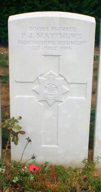
![Devonshire Cemetery, Mametz. [Copyright 2018: A. Matthews]](https://greatwardiaryontour.files.wordpress.com/2018/11/img_20180908_182641517_44508635202_o-2.jpg?w=1100)
![A tribute to the Australian soldiers at Pozières [Copyright 2018: A. Matthews]](https://greatwardiaryontour.files.wordpress.com/2018/11/dscn8164-2.jpg?w=237&h=341)

![Inside Amiens Cathedral. [Copyright 2018: A. Matthews]](https://greatwardiaryontour.files.wordpress.com/2018/10/img_20180908_103252169_hdr_30687745638_o-2.jpg?w=338&h=410)
![Amiens Town Hall [Copyright 2018: A. Matthews]](https://greatwardiaryontour.files.wordpress.com/2018/10/dscn8120-2.jpg?w=381&h=294)
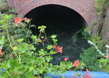
![The River Somme [Copyright 2018: A. Matthews]](https://greatwardiaryontour.files.wordpress.com/2018/10/dscn8129-2.jpg?w=1100)
!["The Azaires' house showed a strong, formal front towards the road from behind iron railings. The traffic looping down towards the river would have been in no doubt that this was the property of a substantial man. The slate roof plunged in conflicting angles to cover the irregular shape of the house. Beneath one of them a dormer window looked out on to the boulevard. The first floor was dominated by a stone balcony[...] There was a formidable front door with iron facings on the timber." No. 39 Boulevard du Cange [Copyright 2018: A. Matthews]](https://greatwardiaryontour.files.wordpress.com/2018/11/dscn8133-2.jpg?w=1100)
![Hortillonages [Copyright 2018: A. Matthews]](https://greatwardiaryontour.files.wordpress.com/2018/11/dscn8137-2.jpg?w=394&h=528)
![Hortillonages [Copyright 2018: A. Matthews]](https://greatwardiaryontour.files.wordpress.com/2018/11/dscn8138-2.jpg?w=1100)
![La Targette French and British cemeteries [Copyright 2018: A. Matthews]](https://greatwardiaryontour.files.wordpress.com/2018/10/dscn81091.jpg?w=1100)
![The view from Kemmelberg [Copyright 2018: A. Matthews]](https://greatwardiaryontour.files.wordpress.com/2018/10/img_20180907_105244434_hdr_44558095661_o-2.jpg?w=591&h=447)
![Kemmelberg rising from the flat farmland of Flanders [Copyright 2018: A. Matthews]](https://greatwardiaryontour.files.wordpress.com/2018/10/dscn8087-2.jpg?w=1100)
![Craters at Vimy Ridge [Copyright 2018: A. Matthews]](https://greatwardiaryontour.files.wordpress.com/2018/10/dscn8099-2.jpg?w=1100)
![The (rebuilt) Cloth Hall in Ypres, home to the In Flanders Fields museum. [Copyright 2018: A. Matthews]](https://greatwardiaryontour.files.wordpress.com/2018/09/dscn8026.jpg?w=1100)
![Reading and drinking the Wipers Times in Wipers [Copyright 2018: A. Matthews]](https://greatwardiaryontour.files.wordpress.com/2018/10/img_20180906_220356556_44519562431_o-2.jpg?w=331&h=588)
![Hill 60 crater as the sun begins to set [Copyright 2018: A. Matthews]](https://greatwardiaryontour.files.wordpress.com/2018/10/dscn8086-2.jpg?w=1100)
![Sheep grazing at Hill 60 [Copyright 2018: A. Matthews]](https://greatwardiaryontour.files.wordpress.com/2018/10/dscn8077-2.jpg?w=1100)
![Caterpillar Crater [Copyright 2018: A. Matthews]](https://greatwardiaryontour.files.wordpress.com/2018/10/dscn8082-2.jpg?w=1100)
!["ComingWorldRememberMe" at Palingbeek [Image copyright 2018: A. Matthews]](https://greatwardiaryontour.files.wordpress.com/2018/10/img_20180906_174247100_hdr_29578404987_o-2.jpg?w=1100)
![Front lines at The Bluff: nearest hedge (and memorial tree) is Allied line, opposite hedge is German line [Copyright 2018: A. Matthews]](https://greatwardiaryontour.files.wordpress.com/2018/10/img_20180906_175300822_42706954500_o-2.jpg?w=1100)

![The Poelcapelle British Cemetery register [Copyright: A. Matthews]](https://greatwardiaryontour.files.wordpress.com/2018/10/img_20180905_132933201_42686634290_o.jpg?w=1100)
![Private E. W. Rogers, Royal Berkshire Regiment, 12th October 1917; A Soldier of the Great War; Serjeant E. C. Drew, Royal Berkshire Regiment, 12th October 1917. [Copyright 2018: A. Matthews]](https://greatwardiaryontour.files.wordpress.com/2018/10/img_20180905_133906515_43586239515_o-2.jpg?w=1100)
